Saint-Méloir-des-Bois
| Gemeente in Frankrijk | |||
|---|---|---|---|
.svg.png) | |||
 | |||
| Situering | |||
| Regio | Bretagne | ||
| Departement | Côtes-d'Armor (22) | ||
| Arrondissement | Dinan | ||
| Kanton | Plancoët | ||
| Coördinaten | 48° 27′ NB, 2° 15′ WL | ||
| Algemeen | |||
| Oppervlakte | 6,13 km² | ||
| Inwoners (1 januari 2023) |
270[1] (44 inw./km²) | ||
| Hoogte | 50 - 122 m | ||
| Overig | |||
| Postcode | 22980 | ||
| INSEE-code | 22317 | ||
| Website | Officiële website | ||
| Detailkaart | |||
 | |||
| Foto's | |||
_%C3%89glise_Ext%C3%A9rieur_03.JPG) | |||
| Église Saint-Méloir[3] | |||
| |||
Saint-Méloir-des-Bois is een gemeente in het Franse departement Côtes-d'Armor in de regio Bretagne en het arrondissement Dinan. De gemeente telde 270 inwoners op 1 januari 2023.[1]
Geografie
De oppervlakte van Saint-Méloir-des-Bois bedraagt 6,13 vierkante kilometer. Op 1 januari 2023 was de bevolkingsdichtheid 44 inwoners per km².

Demografie
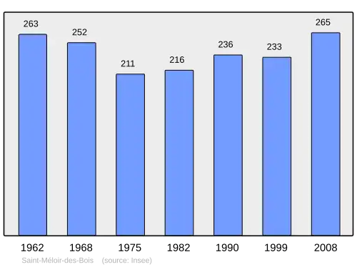
Onderstaande figuur toont het verloop van het inwonertal.[4]
Bronnen, noten en/of referenties
- 1 2 Populations de référence 2023.
- (fr) Eglise paroissiale Saint-Méloir (Saint-Méloir-des-Bois) op de Base Mérimée van het POP
- ↑ (fr) Eglise paroissiale Saint-Méloir (Saint-Méloir-des-Bois) op de Base Mérimée van het POP
- ↑ (fr) Statistische informatie op de website van het Franse bureau voor statistiek INSEE, cijfers inwoneraantal volgens de definitie "population sans doubles comptes".
Zie de categorie Saint-Méloir-des-Bois van Wikimedia Commons voor mediabestanden over dit onderwerp.