Montmirail (Sarthe)
| Gemeente in Frankrijk | |||
|---|---|---|---|
.svg.png) | |||
 | |||
| Situering | |||
| Regio | Pays de la Loire | ||
| Departement | Sarthe (72) | ||
| Arrondissement | Mamers | ||
| Kanton | Saint-Calais | ||
| Coördinaten | 48° 6′ NB, 0° 48′ OL | ||
| Algemeen | |||
| Oppervlakte | 12,53 km² | ||
| Inwoners (1 januari 2023) |
366[1] (29 inw./km²) | ||
| Hoogte | 122 - 227 m | ||
| Overig | |||
| Postcode | 72320 | ||
| INSEE-code | 72208 | ||
| Website | Officiële website | ||
| Detailkaart | |||
 | |||
| Foto's | |||
 | |||
| Gemeentehuis | |||
| |||
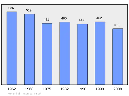
Montmirail is een gemeente in het Franse departement Sarthe (regio Pays de la Loire) en telt 462 inwoners (1999). De plaats maakt deel uit van het arrondissement Mamers.
.jpg) Kasteel van Montmirail
Kasteel van Montmirail
Geografie
De oppervlakte van Montmirail bedraagt 12,4 km², de bevolkingsdichtheid is 37,3 inwoners per km².
Demografie
Onderstaande figuur toont het verloop van het inwonertal (bron: INSEE-tellingen).
Externe links
- (fr) Statistische informatie op de website van het Franse bureau voor statistiek INSEE
Zie de categorie Montmirail (Sarthe) van Wikimedia Commons voor mediabestanden over dit onderwerp.
- ↑ Populations de référence 2023.